El Chepe

The Grand Canyon at the border of Arizona and Utah is 446 km long and at its widest point 29 km across. It is over a mile, at its deepest maybe even 1857 m, deep. If the depth is defined by the difference between the river level and the highest mountain at the rim it is a shallow ditch compared to Cotahuasi Canyon in Peru with 3354 m. But the winner is Yarlung Zangbo Grand Canyon in Tibet with a depth of up to 6009 m. The deepest in Europe is the Canyon of the Tara river in Montenegro, which is about a kilometer deep.

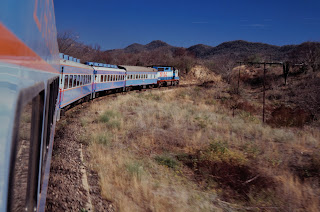
Chepe crossing a down bound freight train
Not far from the Grand Canyon by continental standards is el barranco del Cobre in Mexico. It supposedly is 1879 m deep. In fact it is a system of 6 Canyons all draining into the Rio Fuerte, which dumps its waters into the Gulf of California near the port town of Los Mochis. The area covered by the barranco is six times that of Grand Canyon. Copper Canyon has one added attraction: it can be enjoyed from a train, the so-called Chepe.

A railway links the port of Topolobampo near Los Mochis on the Pacific coast with the provincial capital at Chihuahua in the interior and eventually after 953 km the border with Texas at Presidio. The 653 km of the line between Los Mochis and Chihuahua are the only railway in Mexico with long distance passenger traffic. There is a daily local train which takes 15 hours and 28 minutes and an express for tourists which runs along the most spectacular section along the canyon between Los Mochis and Creel three times a week. Face masks are required and a temperature check is carried out before boarding.

On the route the train has to master the heights of the Sierra Madre Occidental. That involves a climb from sea level at Los Mochis to 2420 m at the summit.

Already in the 19th century a concession was given to an American company to build a railroad between the border with Texas and the Pacific coast. The idea was to open an alternative and shorter route from a pacific port to the American midwest. The distance of 2800 km between Los Mochis and Kansas City is about the same as between San Francisco and Kansas City. However, because of the difficult terrain, financial problems and the political situation (the mexican revolution between 1910-1920 ended the long rule of Porfirio Diaz, dictator since 1876) the construction took a long time. The concession changed hands several times. In 1897 the “Chihuahua al Pacífico” of Enrique Creel (after whom later the town and station was named) and Alfredo Spendlove (!) built 194 km of track in the state of Chihuahua, Between 1902 and 1908 the Kansas City, México y Oriente Railway built two short disconnected sections in Chihuahua and Sinaloa and between 1910 and 1914 the section between the border with Texas and Chihuahua. In the same time Enrique Creel’s Chihuahua al Pacífico railroad built the Chihuahua-Creel section.

Driving in the semi-desert
In 1940 the Mexican government acquired the whole mess and renamed it Ferrocarril Chihuahua al Pacifico. The most difficult section of 258 km across the Sierra Madre between Creel and Heriberto Valdez was still missing. It was finally completed by the Mexican government on November 24, 1961. Construction and reconstruction of the line took enormous technical and human efforts to overcome the obstacles of the imposing Tarahumara Mountains. 90 million dollars were spent. The railway is still a vital link to the coast and also serves the local communities since there is no parallel road.

The skyline of Guyamas
In early 1989 a friend came for a visit to Pasadena and she was adventurous enough to go for a trip down to Sonora and Sinaloa. It is 1600 km from Los Angeles to Los Mochis. We took the border crossing from Calexico to Mexicali and first followed Mexican route 3 along the coast, after Hermosillo route 15 past the port town of Guyamas. This part of the coast has so many empty sandy beaches that even the Gringo developers were not able to fill them. Once the coast is left behind there only is empty scrubland, a desert sometimes dotted with huge cacti which, then in April, either displayed a parade of white flowers or brown, prickly balls. The few barren mountains disappear in the haze. Along the road are some isolated dusty settlements. No landscape is more prototypical suitable for filming a Western movie than the empty expanses of Sonora.


The route was too long to be driven in one day and so we stayed in a place along the beach of a protected bay near Guyamas. From there it was not much more than 4 hours to Los Mochis and so we made a little detour to the town of Alamos, a colonial town in the foothills of the Sierra Madre, which could serve as the architectural background for said Western movie I plan to record in Sonora. Alamos has a lot of history on its own.


There was a treasure in the Sierra Madre. In 1683 silver was discovered in this area. Alamos became a boom town with a population of 30.000 and one of Mexico’s principal mining centres of the time. Haciendas, mansions, a cathedral, a building housing the royal mint and numerous workshops were built.


After Mecican independence in 1821 Alamos became the capital of the state of Occidente, a huge area including all of the later Mexican states of Sonora and Sinaloa. The owner of the richest silver mine, Don José Maria Almada, became the governor.


In the turmoil of Mexican history the wealthy mining settlement of Alamos attracted attention. First of all, the Yaqui indians living in the surrounding area managed to maintain their independence until the early 20th century and regularly raided the town. During the revolution the rebels followed their example. A timeline of the chaos of the time can be found on the town’s website. Most of the inhabitants left. By 1920 many of the beautiful haciendas and mansions in the town had fallen in disrepair. The place had practically become a ghost town.


But the fate turned again in 1948. In this year Pennsylvania dairy farmer William Levant Alcron arrived. He liked the cobble stone streets, and saw a potential in the plazas, arches, ornate iron-work, carved wood doors, high ceilings, five-foot thick walls and proximity to the United States border. He bought many of the ruins and restored governor Almada’s mansion to become the Hotel Portales. Alcorn managed to bring publicity to Alamos and made a fortune selling his ruins for a good price. Many gringos arrived, lovingly restored the crumbling haciendas and mansions and brought Alamos back to its former glory. Alcron died in 2004, almost 100 years old, and, according to the “lonely planet” of 1998, could still regularly be seen in an arm chair at the entrance of his hotel.

The Aguacalieate bridge
To take the train we have to stay in Los Mochis where we also can store the car in the courtyard of the hotel. The train leaves early and until we reach the stop at El Fuerte passes through the subtropical heat of the pacific plain. Then the line rises quickly and crosses the Rio Fuerte over the “Aguacaliente” Bridge, which is 45 meters high and 498.5 m long.

View from the bridge
To climb from sea level to 2420 m at the summit 37 bridges with a total length of 3,6 km and 87 tunnels with a total length of more than 17 km had to be built. The longest tunnel is “El Descanso” with 1,838 meters. When it was built it was the longest in Mexico.

Temoris

Freight train climbing up Temoris

Tunnels and bridges were not enough to cross the high and rugged mountains. At “Temoris”, the railway has to spiral up the mountain in three layers involving bridges, viaducts and the 937 m “La Pera” tunnel. The name, pear, stands for the shape of the tunnel.

People at the stops underway

The train takes a long rest at the station Divisadero. Here a viewpoint allows to gaze down into the Urique Canyon of the Barranca del Cobre, the confluence of 3 canyons. From the viewing platform the bottom of the abyss is 1600 m below.

View down into the canyon
To reach the summit, the train climbs through another spiral, “el Lazo”, where the line passes over itself on a bridge and in a tunnel.

Stop at Divisadero
By then, the heat of the pacific coast has long given way to a cool alpine mountain climate. Endemic pine trees have replaced the cactus forests of the desert low land. The line passes the crest of the Sierra Madre Occidental through the “Continental” Tunnel, 1,260 meters in length. It got its name because the tunnel crosses the Western Sierra Madre watershed.


Creel, atop the canyon at 2,350 metres, was the end of the line for 50 years. Once it was a railway town with not much more than a dusty main street and the station. But now the railway brings tourists and the guesthouses along the main street organise trips down into the abyss of the canyon. The trips are done in open buggies so that the dust can be enjoyed even more.

Main street in Creel

Sign of the bakery in Creel
The arrival of the tourists at least has the advantage that they were busy building sewers in the main street which probably lead their contents right into the river at the bottom of the canyon without the detour of the creeks and waterfalls running to the bottom. We got a room in a dusty guesthouse and reserved a trip to the bottom for the next day.

Sewer works in the main street

Invitation to enter

This is the world of the Tarahumara Indians. Once they were living all over the north eastern part of Mexico. Unlike the Yaquis, who stood their man against the Spaniards, the Tarahumara retreated into the solitude of the Sierra Madre. In their own language they call themselves Rarámuri, which means "runners on foot" or "those who run fast". Since their villages are widely dispersed they developed the ability of long-distance running up to 320 km over a period of two days through their homeland of rough canyon country for communication, transportation, and hunting. They were urged to participate in international running competitions like Marathon, but they proudly denied, that being a distance far below their level.
In the station of Creel

Tarahumara Indians in the station of Creel

Tarahumara women sell pottery

The author Christopher McDougall has written a book about the Tarahumara's incredible running capabilities: “Born to run”. He argues that they are mainly able to do that because they do not use modern soft running shoes but huaraches, a traditional form of minimal footwear which leaves them practically running barefoot.


The long-distance running tradition is also combined with games of kicking wooden balls or relaying sticks and hoops which can last for up to a couple of days without a break. The running ability is also used for hunting: in addition to using bow and arrows, the Tarahumara are known to run down deer and wild turkeys which collapse exhausted from the flight away from the hunters.

Buggies waiting for the trip into the canyon

At the bottom of the canyon

Stable in the Sierra Nevada

When Paul Theroux made his epic trip down the entire american double continent which led to the publication of the famous book “the old patagonia express” in 1975 he still was able to take three long distance trains in Mexico. The “Aztec eagle”, which brought him from Nuevo Laredo at the border to Texas to Mexico city, had old sleeper cars bought second hand from some bankrupt railway company in United States, a dining car, newspapers and tequila. Another night express, now without dining car, but still with tequila, allowed him to cover the second third of the expanse of this big country down to Vera Cruz. The train was called Jarocho, which means “boor, rude person”, a name which would not motivate many to buy a ticket. And there was another train for the last leg of the journey, some 800 km from Vera Cruz to Tapachula at the border to Guatemala. He wrote in his notes:
“Two classes, both uncomfortable and dirty. No privacy, no relief. Constant stopping and starting, broken engine, howling passengers. On days like this I wonder why I bother: leaving order and friends for disorder and stangers. I’m homesick and feel punished for my selfishness in leafing”.


Like in most other countries on the American continent, but in particular central and south America, railways in Mexico are neglected and only used for freight traffic, if at all. Except El Chepe all the long distance trains have been discontinued in 2000 after the Mexican government has stopped subsidies. However, the internet is full of plans for a revival of passenger trains. There are even projects for a high speed network. There were plans for investments by the Chinese, but the contracts were never fulfilled and the Mexican government had to pay a high compensation for the cancellation. It seems that even the Chinese were unable to overcome the latin american circumstances and probably US resentments against Chinese investments so close to their front door. So El Chepe is still the only long distance passenger train in Mexico.

In the station of Creel. The line inspector car is now a monument in Los Mochis

There is a website which collects information about railways in Mexico. Their information about current train travel starts with:
“Due to extraordinary conditions, MEXLIST strongly suggests that Americans and other foreign nationals contemplating travel in Mexico should study the U.S. Department of State's Mexico Travel Advisory or the equivalents from their own governments.”

Dining car of El Chepe
El Chepe had a tidy and empty dining car. It was clean and not considerably late. After the train has brought us back down to the coast we take the ferry from Los Mochis across the Sea of Cortez to La Paz in the south of Baja California. Corona story number 17 shows the wonders of this incredible peninsula:

The ferry to baja california

Fishing boats in the bay of California

Arrival in La Paz

Sources:
Christopher McDougall: Born to Run: A Hidden Tribe, Superathletes, and the Greatest Race the World Has Never Seen, (Knopf, 2009. ISBN 0-307-26630-3)
https://www.spiegel.de/reise/fernweh/mit-dem-chepe-zug-durch-den-norden-mexikos-reisen-a-901399.html
Paul Theroux, the old patagonia express, Penguin Classics, 2008

Sunset at the bay of Guyamas
