How to live with volcanoes?

Most volcanic activity is caused by the tectonic plates pushing against each other. But there are also so called hot spots, areas of overheated magma which weaken the crust above and cause thinning and melting and break through which results in volcanic activity above the hot spot. Since the tectonic plates move above the hot spot a chain of volcanoes is created. While older ones are left behind extinct on one end of the chain, new ones are formed at the other end. Hot spots can be under the oceans or under the surface of the continents. Supposedly there are more than 40. The most famous visible manifestations are the Hawaiian islands, Yellowstone, the Galapagos islands, Cabo Verdean islands, Madeira, the Azores and the Canary islands. But also very close by, the presently dormant Eifel volcanoes were caused by a hotspot. There seems to be an eruption every 60.000 years. The last one 60.000 years ago threw ash as far as the south of France...

In Tazacorte...

...the main town on the west coast of La Palma

Of the seven major islands of the Canarias, four are volcanically active: Tenerife, El Hierro, La Palma and Lanzarote. The Teide volcano on Tenerife is the third tallest volcano on Earth on a volcanic ocean island. In the summer of 2011 a series of low-magnitude earthquakes occurred beneath El Hierro followed by a submarine eruption producing gases and pumice.

Ruin of a windmill
However, together with Tenerife the most volcanically active of the Canary islands is La Palma. Since the Spanish have kept records, there have been eight eruptions which all have occurred in the area of Cumbre Vieja:
1470–1492 Montaña Quemada
1585 Tajuya near El Paso
1646 Volcán San Martin
1677 Volcán San Antonio
1712 El Charco
1949 Volcán Nambroque at the Duraznero, Hoyo Negro and Llano del Banco vents
1971 Volcán Teneguía
As everybody meanwhile knows the latest eruptions started on 19th September 2021 after earthquakes at Volcán Tajogaite.

Our little house in Tijarafe
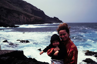
In 2001, with a little baby of 18 month we decided that we needed a break. We were fortunate enough that my mother was willing to come along as a babysitter. As accommodation we rented a beautiful little house with a big view in Tijarafe in the northwest of the island. In the morning the house was just high enough up on the slope above the coastal cliffs that the mist stayed in a layer above the sea below us. The slopes had some orchards, but there was no village close by. A few old houses looked abandoned. A narrow access road led to the house. For today’s standards it was rather simple, a couple of sparsely furnished bedrooms, a kitchen and living room and a big terrace overlooking the sea. No swimming pool which only would have caused paranoia about the danger for a mobile baby.

Houses along the old country road near Tijarafe

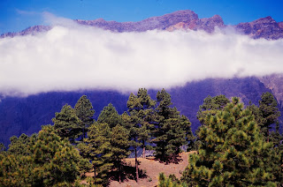
La Palma is a drop shaped island. The base lies almost 4,000 m below sea level and reaches a height of 2,426 m above sea level. Most of the coast is formed by steep ocean cliffs. The northern part of the island is formed by the caldera de Taburiente. About a half a million years ago, the Taburiente volcano collapsed with a giant landslide, forming a caldera with a diameter of 10 km and in parts a depth of 2000 m. From the caldera running south a chain of more recent volcanic craters forms the crest of the island. The caldera of the Taburiente volcano was designated a national park in 1954.

The caldera of Taburiente

Exit of the caldera
The presence of my mother as a babysitter allowed us to do some hiking without need to carry around the baby in a backpack. The caldera of the volcan Taburiente was close by. The caldera is open on the western side and allows a lively stream of water leaving the volcano via the Barranco de las Angustias. Because of the height the upper slopes of the crater are covered by a shady forest of pines. There is a trail along the water into the caldera with nice spots to have a refreshing dip. Other trails follow the rim of the enormous crater.

Hiking along the rim of the crater
The collapse of the Taburiente volcano must have been an enormous event with far reaching consequences although the crater itself probably was formed by erosion. Basaltic ocean islands such as the Canary Islands tend to experience catastrophic landslides every few hundred thousand years. For example, the 1883 eruption of Krakatau, Indonesia, caused a tsunami killing tens of thousands. Scientists have calculated the flood resulting from the collapse of a significant portion of an island with a potential to displace vast amounts of seawater. A simulation by Ward and Day made in 2001 describes a doom scenario which seems to have been taken right out of the plot of a Hollywood movie. The landslide would instantaneously create a water dome of 900 m high above La Palma. A flood wave more than 50 m high would reach the African coast in less than 60 min, a tsunami of 25 m high would reach the Florida coast after 9 hours. Spain, and even France would be affected by flood waves of 5-7 m high. The study later was criticized and it is improbable that a landslide causing such an enormous tsunami ever happened.

While the huge Taburiente volcano is dormant or extinct now, a chain of more recent volcanoes extends from there south. A 23.70 km long hiking trail, the ruta de los volcanes, links the Refugio del Pilar at the caldera de Taburiente with the Faro de Fuencaliente at the southern tip of the island. It is one of the most spectacular hikes I know. The route follows a crest along a moon like landscape of a chain of volcanic craters with only little recent vegetation. We walked in two day hikes. The first day from the Refugio El Pilar via the Mirador de Birigoyo, Hoyo Negro (1 h 47 min, 4,80 km), El Duraznero (Volcán de San Juan, 2 h 17 min, 5,83 km), Las Deseadas (3 h 10 min, 7 km), Volcán de Martín (4 h 30 min, 10,5 km) reaches the little town of Los Canarios after 17,2 km and 6.5 h. The highest point is at 1933 meters in Las Deseadas. In total there is a descent of 1207 meters. From Los Canarios it is necessary to take a bus and taxi back to the starting point at the refugio.

Main street of Los Canarios
This route passes the area of the more recent volcanic activity on La Palma. The 1949 eruption in the Duraznero, Hoyo Negro and Llano del Banco vents caused a lava flow which ended up forming a lava delta, a peninsula stretching out into the Atlantic ocean to the west. It can be seen from the hiking trail at the crest of the chain of craters. After 50 years much of these deposits is covered in green houses and recent buildings.
The peninsula ....

.... and the old vent of the previous eruption ....

..... are also the site of the current activity

Volcan Duraznero
Starting on September 19th, 2021, the Cumbre Vieja area of the La Palma volcano started erupting again. Following the collapse of part of the interior cone the size of the lava lake increased and lava flows spilled down the side of the mountain. With the lava, ash was ejected and on September 25th La Palma Airport suspended all flights due to ash accumulation. Sometimes dense and billowing ash-and-gas plumes rose up to 2.8-4 km above sea level. Up to 53.600 tons of Sulfur dioxide were emitted per day. Some lava fountains rose up to 600 m above the vent. Big junks of rock were spat out, which sometimes drifted downhill like boats on the sea of lava.

The craters of Las Deseadas along the ...

... ruta de los volcanes.

The Hoyo Negro crater

Volcan de Martin

The lava flows reached the sea and a lava delta reached to 120 m water depth. The thickness of the flow at the delta was 10-30 m and covered an area of about 0.11 square kilometers. The new lava delta is not far from the one formed in the eruption of 1949.

At the horizon to the right the Island of La Gomera and to the left ...

.... el Teide volcano on Tenerife

The eruptions were accompanied by seismic activity. Some of the shocks were not only felt by the local residents, but also on La Gomera and Tenerife.

Volcan San Antonio

The eruption has caused the evacuation of around 7,000 people, and by october 29th the lava flow had covered 946 hectares. At that point 2532 buildings had been destroyed, including the entire town of Todoque. What was not destroyed was covered by a thick layer of ash. In brief interruptions of the lava flows and ash rains desperate homeowners returned to retrieve stuff. Since the area flooded by the recent lava flows was so close to the previous flows from not even 100 years ago a certain risk of new volcanic activity could have been expected. Apparently there were no volcano related building restrictions in this area. It will be interesting to wait how long it will take until development will start anew after the present activity has ceased.

The lighthouse of Fuencaliente
In a second day we walked from Los Canarios to the lighthouse Faro de Fuencaliente (6,7 km one way) at the southern tip of the island. On the way Volcán de San Antonio and Volcán de Teneguía are passed. This is the area which was most affected by the eruptions of the Teneguia volcano in 1971. In 2001 these activities were only 30 years ago and the area looked even more like a moonscape that the Cumbre vieja area the other day. A black landscape of desolation with, as backdrop, the blue sea.

The salt pans at Fuencaliente
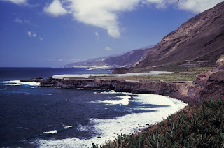
Next to the lighthouse rock pools are used to evaporate sea water to produce salt. On the other side is a beach. Like most beaches in La Palma it is black. Swimming on these beaches is dangerous and most wave the red flag throughout the year.

The port and beach of Tazacorte
When we had a rest on one of the beaches at Tazacorte, my mother had disappeared. Not realising the red flag she had still tried to have a dip. In one of the big waves she had lost her foothold and was turned upside down. We got alarmed when we saw legs and feet briefly appear above the water and then disappear. I started to run and together with another helpful soul we dragged her out of the water. She had almost fainted and her sense of up and down had disappeared. After we had safely returned to solid ground one of the beach’s bay watch heroes appeared and reproached her angrily about entering the water. He should have made his reproaches when he saw her going in and not afterwards.

The beach of Tazacorte
At points where the bottom of the steep cliffs can be reached the islanders have built boat houses which also seem to have a second life as vacation homes. Frequently there are concrete pools which provide safer spots for a dip. But even there, with high surf, a big wave can flood a pool in a wink.

The fishing coves of Puntagorda ....


.... and Playa Jurada

In the time of corona with tourists staying away and lockdowns blocking tourism for entire months an economy like the one of the canary islands is in despair. Nevertheless the official tourist board for La Palma tries to market the 'Isla Bonita'. Tourists come in big numbers to watch the volcanic activity. They neither seem to be scared away by the many quakes registering up to 5 on the Richter scale (such as on sunday 30.10.) nor the risk of cancelled flights after airport closures due to ash clouds. La Palma's local council even launched a transportation plan with free shuttle buses for all those who wish to visit the volcanic area. The volcano is not seen as a threat but as a chance….

Endemic plants of the Canarian islands

Dracena draco

euphorbia canariensis

Sources:

The port of Tazacorte
Previous post about volcanism:
Puntagorda

Tazacorte