Dawn of a new day

Havasu fall next to the campground
While you start reading this I recommend the following background music (scroll down, look for the link to the church house blues and click on „listen in browser“:)

The Bureau of Indian affairs manages the reservations
“There is temptation in the bottle, redemption in the bible”

Drunk Indian with son on the back of a pick up truck
Crystal’s father was a truck driver. Sometimes she went with him on his trips. At a certain point she got the chance to hitch a ride down to Nashville, Tennessee in the hope that somebody would like her music. They probably did, but they told her that nobody would buy the music of a full-bloodied native American. She went back to Canada.
If you liked the first song you can continue here
Even in these modern years the situation of the native American nations is bleak

Indian settlement in the Arizona steppe
For at least 800 years the Havasupai people, the people of the blue green waters, lived in a remote valley of a southern tributary to the Colorado river at the Grand Canyon. The Havasupai are one of the seven bands of the Hualapai Indian tribe, but due to US government policies ended up in a separate reservation south of the Grand Canyon.

Gas station on route 66 in Peach Springs, Arizona, Capital of the Hualapai nation
The Havasupai live in a canyon which is watered by the blue green flow of a hidden limestone aquifer that nourished the fields of corn, squash and beans which allows the tribe to survive in the harsh reddish desert landscape deep in the Grand Canyon for centuries. When the spanish priest Francisco Garces first encountered the Havasupai in their valley, he counted 320 people. The valley was very remote and therefore for a long time the Havasupai were largely untouched by the changes around them. They even were not affected by the Hualapai Indian war between 1865 and 1870, which caused the death of a big part of their relatives to the west. However, in 1870, silver was discovered in the canyons and a flood of prospectors started to appear. In 1880 the tribe managed to obtain a small federally protected reservation from president Rutherford Hayes, yet it did not include the mining areas along the Creek. Still today, tunnels, rails and timbers can be found. Lead was mined here for the last time during WWII.

The Grand Canyon
In 1882 President Chester A. Arthur declared most of the tribe’s land public property of the United States. The order reduced the Havasupai to a 2.10 km2 plot of land in Cataract Canyon, taking almost all of their aboriginal land. However, for several years, the Havasupai were completely unaware of the act. But as the number of settlers increased the game they relied on for food was depleted, soil erosion caused poor harvests and food shortages and the contact with their new neighbours led to the outbreak of waves of smallpox, influenza, and measles. By 1906 only 166 tribal members remained.

Meanwhile the Grand Canyon had been discovered as a major attraction. By 1901, the Santa Fe railroad opened a line to the south rim of the canyon. When President Theodore Roosevelt visited the Grand Canyon in 1903, he told two Havasupai he met that a national park was about to be created. They would have to leave the area. Eventually, by 1928 the Havasupai had to leave from areas inside the park limit.

Helicopter with a group of tourist in the center of the village
The decrease of their land and increasing poverty reduced the morale throughout the tribe, leading to an increase in gambling, alcoholism, and violence. Poor health lead to high infant mortality and the loss of almost an entire generation. The Havasupai realized that they could not hope to survive without adapting to the changing circumstances. Their options were breaking horses, working on farms, or even serving as employees of the National Park. However, the National Park Service generally was not helpful. Actions such as razing residents' traditional homes and replacing them with cabins showed the intentions of the Park Head Quarters: they wanted the final 2.10 km2.

The upper part of the reservation in the desert
However, the tribe fought back. In 1968 they won an Indian Claim Commission case against the United States to have the land that had been taken returned to them. Eventually, after much intentional delay, on January 4th, 1975, the Havasupai were granted a title to approximately 750 km2 of land. Another 386 km2 were designated as "Havasupai Use Lands," to be overseen by the National Park Service, but available for traditional use by the tribe.

The shadow less parking lot
The number of people of the blue green waters recovered. Today the tribe has 730 members, of whom 400 live in the reservation. The place is still remote. From Peach Springs, the centre of the neighbouring Hualapai reservation on historic route 66, it is a hot and dusty ride of 93 km of gravel road to a parking lot. From there it is another hike of 13 km down 600 m to the village of Supai. This remoteness creates many obstacles. Everything, including the mail from the village’s US post office must make the trek in and out either by foot, or on horseback. Above a temperature of 115°F (46°C) or chance of flash flooding the trail is closed. Privileged and environmentally ignorant visitors can be flown in by helicopter. All visitors must make a reservation either for the campground or the lodge. Strict rules apply: no alcohol, no drugs, no drones, no weapons, no nudity. However, the Havasupai trail is the most pleasant, spectacular and least crowded hike into the depth of the Grand Canyon.

Start of the trail at the parking lot
There was no lodge nor drones in 1990, but we had made a reservation for the campground. Additionally, reservation and payment of the entrance fee was required to enter Grand Canyon National Park just below the village. The parking lot was baking in the hot desert sun, but obviously the 115°F were not yet reached. So we shouldered our back bags with tents, cooking gear and food for some days and started to hike down into the valley.

Mule train to bring provisions to the reservation


In switchbacks the trail drops down steeply. To the right the inhospitable hot red desert surface of northern Arizona. There is no indication that anybody could make a living in this oven, but these highlands were used by the Havasupai as winter quarters until they were taken away by limiting them to their little reservation. After a while we enter a shady valley between vertical red cliffs and the first water appears between the rock faces. We are overtaken by a mule train which carries the provisions for the village ahead of us. Before we encounter the first buildings, we see the landmark of the village, the watchers, a pair of stone pillars on top of the red canyon wall.


The village has a little cafeteria, a medical post, a store selling basic provisions and the helicopter landing spot. We sign the visitors register and continue to the campground, another 3 km and 100 m of height down the valley. This is the area of the famous Havasu water falls. The blue green water gushing down the cascade collects in white travertine terraces formed from the limestone dissolved in the water. The campground is just off the pools. We are the only campers. Water comes from a well flowing out of a crack in the rock. After the long trek in the sun this fresh water definitely feels like the best drink I ever had. Since alcohol is not permitted on the reservation the well and the soft drinks from the store in the village are the only refreshments available.

The cultivated part of the reservation in the upper valley

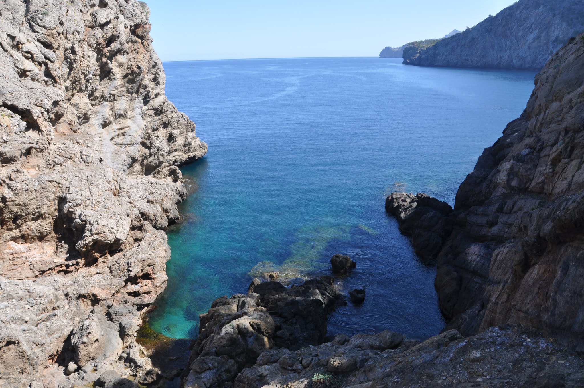
From the campground a trail leads down to the bottom of the Grand Canyon at the confluence of the Havasu river with the Colorado. Up and down it is a day trip. Parts of the trail are in the river bed or cross the river which in some parts is waist deep. We pass more travertine terraces and water falls while the red cliffs lining the canyon get increasingly higher and shut out the sunlight. Chains help to pass difficult passages over rock falls and boulders. Signs at the entrance to the trail warn of snakes and scorpions. When we arrive at a small clearing in an overgrown part of the trail we see a long black and white snake basking in the sun. It probably was a harmless California King Snake but we are scared enough to continue while making noise and stamp on the ground to chase the creatures away. Eventually we arrive at the confluence where the green-blue waters of the Havasu river meet the muddy brown flood of the Colorado. Canoes are parked on a ledge above the water but we do not see anybody. We have the valley for us.

The overgrown part of the trail

Meanwhile, tourism became the main source of revenue for the Havasupai tribe. The valley receives 30,000 to 40,000 visitors per year. After the outbreak of Corona, however, the reservation is closed for visitors while adjacent Grand Canyon National Park and Grand Canyon Parashant National Monument remain open. In 2019, almost 6 million visited Grand Canyon National Park. 52.000 used a backcountry campsite.

The Havasupai reservation is governed by a Tribal Council of 7 elected by tribal members every second year. 5 out of those 7 are women. Law enforcement is provided by the US government Bureau of Indian Affairs.

Mooney fall on the way
Beginning in the 1960s, an extraordinarily high incidence of Type 2 diabetes led to amputations, even among the younger members, and forced many to leave the canyon for dialysis. The tribal council got into contact with researches from Arizona State University and from 1990 on, started to convince members of the tribe to give blood samples for DNA study to university researchers in the hope that they might provide genetic clues to the tribe’s devastating rate of diabetes. A connection between diabetes and genetics had been found with the people of the Pima, another indian tribe. Roughly 100 tribe members gave blood between 1990 and 1994.

The trail to climb down the water fall
However, the geneticist responsible for the research, Therese Markow, had obtained a wider ranging permission for consent to “study the causes of behavioral/medical disorders.”. Next to the study of a connection between genetics and diabetes (which turned out to be negative), a big number of other papers were published. One reported a high degree of inbreeding possibly causing a higher susceptibility to disease. Another article suggested based on the genetic data that the tribe’s ancestors had crossed the frozen Bering Sea to arrive in North America. While the first was regarded as highly offensive by the Havasupai, the latter contradicted the tradition of the tribe, which says that they had originated in the canyon and were assigned to be its guardian. This tradition is the basis for the right of the Havasupai to occupy this area.

Mooney fall from below

To the Havasupai, blood has a deep spiritual meaning. Although university staff also had started programs to help the tribe by nutritional education to reduce diabetes the tribal council issued an order to ban all members of Arizona State University from tribal land. After the university had spent $1.7 million fighting lawsuits by tribe members they finally agreed to pay $700,000 to 41 of the tribesmen, return the blood samples and provide other forms of assistance to the impoverished Havasupai. This legal settlement is far more important than only its implication for a small local group. DNA mining becomes more and more important and research subjects should have the right to be fully informed about how their DNA might be used.

Cataract Canyon

Eventually we had to leave our beautiful campsite next to the travertine terraces and tackle the long climb out in the heat of the day. Fortunately the backbags were much lighter on the way back. Still, after we had arrived at the black furnace our car had become we realized that, after 3 days of abstention, we definitely needed a couple of cold beers. We checked the towns in the surroundings on the map. Peach Springs is Indian territory and therefore not a good place for a drink, Flagstaff as the base to go to the Grand Canyon is full of tourists and Williams ugly. So we decided to go to Prescott.

Travertine terraces on the trail


We found a motel right in the centre, had a decent shower and went for dinner. Then we discovered Whiskey row, a block on Montezuma street with a number of nice old fashioned saloons. First we checked out a place called Bird’s cage saloon (look it up, it still exists), but we were the only guests. When we left after a couple of drinks it turned out that a band was playing in the place next door. After a while it was packed as if the whole younger part of the population of the county was assembled. Some girls noticed our strange accent and asked where from. This is a question we have heard many times on similar occasion in the US. To make things a bit more interesting we answered that we were russian spies. The girls didn’t believe us. We tried hard to convince them that due to Garbatchov there was no more work for us and therefore we now spied out the possibility of exporting russian beer to compete with the undrinkable American stuff. The position was substantiated by numerous rounds of beer until until the bell sounded the last round and we were kicked out.

One of the river crossings

With a bad hangover we woke up the next morning. After breakfast we went for a walk in the town and discovered a western store. It probably still exists (look it up) because we bought a whole outfit there. Next door was a toy railroad store (does not exist any more, nobody nowadays is still interested in model railroads). I bought a whole collection of model kits which today, after 30 years, are still in a box, unassembled. When we got out and walked along courthouse plaza, the central square, a battered huge road cruiser stopped next to us in the middle of the street. One of the girls of the previous evening got out and screamed at us “Russian spies, how are you today?”. We explained to her that we would not have such a hangover if we would have had our good russian beer.

With a car full of cowboy clothes and model railroads we continued our trip to the Island in the Sky section of Canyonlands National Park in Utah (Corona story number 16).

In 2000 Crystal Shawanda went back to Nashville. Again the record companies did not want to give her a contract. So she started having three gigs a night in a club. And indeed, after some time she was discovered by the record company RCA in 2007. When her first album „Dawn of a new day“ was released in 2008 it entered the Canadian Country album charts at number 2 and the the billboard top county albums at number 16. It became the highest charted album by a full-blooded Canadian First Nations country artist.

But Crystal‘s vocation was the blues. She grew up playing blues in the roadhouses and her idols were singers like KoKo Tayler or Etta James. While she was playing country for RCA, Etta James was on her mind. Eventually she left RCA and found her own record company „New sun records“.

The confluence of the Havasu with the Colorado river. The color shows which is which

The unexpected rise to fame of a native american artist captured the imagination. The canadian TV chanel CMT documented her rise in a six-part series „Crystal: living the dream“ and broadcasted it in february 2008.

The Colorado river at the bottom of Grand Canyon
The meaning of her last name „Shawanda“ is „Dawn of a new day“.
‚In the heart you can believe it
In the soul you can feel it
You are bigger than the blues
When you are strong like a river
when you are tall like a mountain
Then you are bigger than the blues“

Sunset over Grand Canyon
Link to the previous post
Other posts about the US:
Sources