The palace of perfect peace
.jpg)
After the attack of the Russian forces on Ukraine a comparison with other conflicts is obvious. With the force of their impressive armament and the threat of using their nuclear weapons the super powers seem to believe that the world has to follow their instructions. The Russians should know better. On christmas day 1979 they invaded the military and economic dwarf Afghanistan. After less than 10 years, in February 1979, they finally gave up. It was not the last time the dwarf prevailed. The Russians were followed by the United States in October 2001. Together with their allies they managed to stay for almost 20 years. Again, the dwarf prevailed.
.JPG)
....determined to complete the plan in 1995....
Also the US could have known better. After a long covered support since 1955, in 1965, president Lyndon B. Johnson ordered a large scale attack on Vietnam. At first, it was announced that it was limited to three years of air strikes at North Vietnam and the Ho Chi Minh trail, but soon, ground troops landed. There was no official declaration of war. Until the Americans finally withdrew in 1973 to leave the Vietnamese to fight on their own, in total 2709918 troops had been deployed, at the peak in April 1969, 569000 at the same time. As an added consequence, the american involvement also drew Cambodia and Laos into the conflict. None of the combatants was better off after the war. The only winners were the shareholders of the industry who provided the material.
%20iv.jpg)
The citadel
.JPG)
In 1954 US president Eisenhower announced the domino theory. It maintained that, if one country in a region came under the influence of communism, then the surrounding countries would follow in a domino effect. The domino theory was used to justify the need for American intervention around the world to prevent communism from spreading to additional countries. The contrary happened. The intervention in Vietnam led to the firm establishment of communism in Laos and Cambodia.
.JPG)
The perfume river
In January 1968, the North Vietnamese and Vietcong launched the Tet offensive in the belief that it would trigger a popular uprising and lead to the collapse of the South Vietnamese government. One of the towns which was attacked was the old imperial capital of Hue.
%20iv2.jpg)
The typical bus
Hue had been capital from 1738 to 1775. In 1802, Nguyen Phuc Anh (who later became emperor Gia Long) succeeded to control the whole of Vietnam. Hue became the national capital under his Nguyễn Dynasty until 1945. In 1820, Gia Long was succeeded by his younger son Minh Mang, who ruled until his death in 1841. Although he was a rigid Confucian orthodox and strongly opposed to the French colonial aspirations, the French came to stay. Hue became the administrative capital of the French protectorate of Indochina. The emperors resided in Hue until the last, Bao Dai, abdicated in 1945. Vietnam became a Democratic Republic with the capital moved to Ha Noi.
.JPG)
Bus in the rain south of Hue
The Nguyen emperors built an Imperial City. It occupied a large, walled area on the north side of the Perfume River. There was a citadel and a forbidden city open only for the emperors, their concubines, servants and relatives. The punishment for trespassing was death. Clearly the inspiration came from the much older and bigger forbidden city in Beijing. But maybe some buildings have inspired the summer palace, which was built only later.
.jpg)
The moat around Hue
We arrived in Hue in a mini van. It had started raining on the way north after we had passed the pass of the clouds. The world around and the city started to drown in mud. Everything became gray, brown, and, in particular, wet. Exception those walking outside. Wearing brightly colored, cheap, blue, red or yellow rain ponchos, they wade through the mire bare-footed. The mini-van drops us in front of a hotel. Instead of continuing through the mud in search of an alternative, we take a window-less room with a stinking toilet. In vain we let the fan run continuously to get rid of the smell.
.jpg)
let's have 2 children to feed my day
The old town still is surrounded by a 12 km long wall. Access is across bridges crossing a dirty moat and gates. The gates are crowned by little towers, some reinforced with concrete bunkers. We climb one. There are cracks and bullet holes everywhere. Below, miserable huts line the stinking broth of the canal. An old red and yellow Renault bus is reflected in the puddles. In the mist ahead a dark mass, the citadel.
.jpg)
One of the entrance gates
In 1969, the citadel housed the division headquarters of the south vietnamese army. Another part of the city was held by approximately 200 Americans. The rest of the city was overrun by the attacking North Vietnamese. The North Vietnamese had calculated that a big part of the South Vietnamese forces were on holiday leave and that the population of Huế would join the fight as part of a general uprising. The fight would last for 25 days and become one of the longest and bloodiest of the Vietnam War. After reinforcements had arrived, U.S. Marines and Vietnamese forces recaptured the city in the pouring rain street by street and house by house.
.jpg)
Finally, on February 25th, the South Vietnamese flag was raised again over what was left over of the Palace of Perfect Peace. Between 1,042 and 5,000 North Vietnamese, 216 U.S. Marines, 421 South Vietnamese and 5,800 civilians had lost their lives, 116,000 out of the original population of 140,000 were homeless since 40–50% of Huế was destroyed by the end of the battle.
.JPG)
The wall around the city
Behind a sodden patch of grass, which is used as a soccer field, appear the ruins of the citadel. Even without any prospect of success, the vietnamese are mad about soccer. The rain is still pouring when we stood in front of the soot covered gate of the forbidden city, or what is left of it,
.JPG)
The gate to the forbidden city
The main gate has three entrances. To the right the vietnamese, at tickets for 5000 dong, may enter, to the left foreigners, for 55000 dong each. The middle entrance was for the emperor only. It is protected by a couple of big plant pots and a screen. We are annoyed. To pay eleven times the price for locals for something what is not more than a field of wet black rubble is rude. While we consider what to do, a local watches us suspiciously.
%20iv2.jpg)
Inside the forbidden city
Finally he disappears. I climb across one of the plant pots and peek around a screen. Nobody is inside. The emperor has returned home. UNESCO and therefore the western world has paid for the reconstruction of a handful of the ruins. In exchange people from these countries are charged an enormous entrance fee. The biggest part of what is left serves as vegetable plots. The few buildings and artifacts on display are not worth the effort to scale the plant pots. At least it is quiet and the drenched ruins ooze a spooky atmosphere.
.JPG)
One of the few renovated buildings
Most of the old town inside the former city walls serves as vegetable garden. It is still drizzling and we leave the remainders of the historic town in search of a dry place. Finally we find a cafe in a run-down old building. At least here we are dry and can watch the traffic in the rain outside. Trishaw’s overloaded with sacks pass with agony, the people on scooters are covered in rain capes. Sometimes several legs and feet extend from one rain cape, as if the scooter would be driven by a beetle. We feel sorry for these poor people, who have to do their jobs and cannot hide in a dry spot like us.
.jpg)
Inside the ruined forbidden city
.jpg)
.jpg)
Most of the buildings are makeshift, in a state between construction, demolition or the provisional. We find a shop selling a replacement battery for one of our cameras, but no decent restaurant. Eventually we walk into one of the better, big hotels along the stinking Huang (perfume) river. In the basement a group of Buddhist monks is assembled around some of the tables set for dinner. One gives a speech in french. Something is wrong here. Eventually we discover that the monks in reality are elderly tourists in monks’ robes. There are no taboos sacred enough to be sacrificed for the money of the tourists.
.JPG)
one of the renovated buildings
.JPG)
Eventually, after some bargaining, we hire a couple of rikshaw drivers to bring us to a restaurant serving a mediocre hot pot with fish. We don’t even try to find a beer bar after dinner and return to our window-less and stinking retreat.
.JPG)
Like in Beijing, the vietnamese emperors built other monuments outside the city proper, in particular the tombs of emperors like Minh Mang, Khai Dinh, and Tu Duc along the Perfume River.
.jpg)
The rain has been replaced by haze and mist and we hire bicycles to find some of the tombs along the river. But those tombs are not so easy to find. We discover the mausoleum of emperor Tu Doc because of an assembly of food stalls and shops, where children press us to park our bicycles “no money”. While we have a drink we inspect the place like generals during a siege. The monument is surrounded by a wall which is very low in patches.
.JPG)
We walk to one low stretch but when we start to climb over, a man appear and points in the direction of the entrance. He obviously thinks we are too stupid to find it ourselves. Or he knows about a better spot to climb the wall in that direction. While we walk along the wall we discover two more gates and then a low spot, which bears traces of frequent trespassing. Inside, the mausoleum of Tu Doc is the most beautiful building we will in Vietnam. And it is quiet and free of hassle.
.JPG)
.JPG)
.JPG)
To get to the Mausoleum of emperor Minh Mang the river has to be crossed. Google maps today displays a bridge, thirty years ago we had to find somebody with a boat although my guidebook of 1994 already shows the bridge. Even before we arrive at the official ferry point, at a quarry we find a woman with a boat. She agrees to ferry us across and back for 10000 Dong. However, after we arrive she wants to have all the money right away. We refuse and disappear. If we pay now we will not find her or will have to pay again after we are back.
.JPG)
The ferry across the perfume river
Again we search in vain for the grave after a boy sends us along the river in the wrong direction. Eventually we find the usual assembly of restaurants near the entrance where we can have lunch. In exchange they will watch our bicycles.
.jpg)
Gates
%20s%20iv.jpg)
The wall around the premises appears to be high and well preserved. We walk along the wall, pass the entrance and continue into a field of bananas, where the wall gets much lower. But when we start to climb across we hear somebody blow a whistle. He must have followed us from the entrance and suspected an evil attempt of trespassing when he saw us entering the banana field. No chance to climb the wall now, not even behind a food stall, where the owner nods approvingly. The whistle man follows us. We give up and turn to another grave site, where they want to charge us 2 $.
.JPG)
Today I regret our greediness. At the time we were so fed up with the constant hassle and cheating that we saw it as a victory to just give up and save a little money, which we easily could have afforded.
.JPG)
greetings customers
looking forward to new year
general industrial crate store
The ferry woman brings us back to the other side, gets her money and we return into town, where we even find a decent restaurant. We meet an exceptional local woman who works for the tourist office. She tells us of her dreams of making a career without being married and depending on a husband. In search for a beer we end up at the stylish, but run-down historic colonial hotel Morin. There we end up meeting old friends, two Irish girls who seems to follow us from town to town. Again the night ends with a hangover.
.JPG)
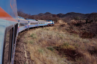
Timetable and the author, still wet from the constant rain
Before we take the night train to Hanoi the next night we want to visit some sights along the river. It is raining the entire day and after 8 km of walking we are completely drenched and there is no way to get dry again before we reach the station in the evening. The reunification express arrives exactly on time and we get to share a dirty 6 bed compartment with an american and an australian. Being on the train you have the impression that it runs at at lest 140 km/h, but when we look at the scenery outside of the former demilitarized zone we realize that it is 70 km/h at the most. But after we have finished a meager dinner of cold rice, thin soup and meat sauce the conductor of the coach comes with fresh bedding, cleans up the compartment and we can sleep until, at six in the morning, the loudspeakers wake us by blasting revolutionary atmosphere into the train. At least the loudspeakers work in this country. And their service is for free.
.jpg)
The reunification express
After the war's conclusion in 1975 the historic features of Huế were neglected because the communist regime saw them as "relics from the feudal regime" of the "reactionary" Nguyen Dynasty. Little of the forbidden city remained, but after the historic sites of Hue were declared UNESCO monuments policy changed and many historical areas of the city were restored and the city is developed as a centre for tourism. Today, this is the towns economic base. Nearly 4.2 million visitors had visited the city in 2019.
.jpg)
Imperial theater
After the recapture of the city until 1970 a number of mass graves were discovered in the city. The victims had either been clubbed or shot or were simply buried alive. The official explanation was that during the occupation the North Vietnamese had rounded up and executed as many as 2,800 South Vietnamese civilians.
.JPG)
.JPG)
The United States were directly involved in the Vietnam war. On the other side, the North Vietnamese were equipped and trained by the Soviets and China. Vietnamese pilots received training on and flew Soviet MIG engines and there was a constant flow of Warsaw pact built vehicles, material and weapons into North Vietnam and along the Ho Chi Minh trail down into the South. The Soviets were involved much in a way comparable to the United States and NATO now in the conflict of Russia in Ukraine. During the Vietnam war the United States did not use their nuclear weapons and as far as I can remember there never was a nuclear threat on that reason.
.JPG)
The domino theory was obsolete after the collapse of the Soviet Union. However, for Russia today, the loss of Ukraine after that of so many of their former allied states to NATO must feel like the beginning of another domino theory with reversed signs. A loss of Ukraine might be followed by a loss of Moldavia, Georgia, Belarus and others to the east. For somebody dreaming of an empire this must be a nightmare.
.JPG)
Link to other posts about vietnam
.JPG)
Link to the previous post
.JPG)
Sources
.JPG)